
Project Description
Urban Forest Geocoding
Address Geocoding / GPS feature data editing
Client: Urban Forestry LLC
Technical POC: Mr Andrew Pleninger
Vice President 119 Yellow Mills Road Palmyra, NY 14522 (315) 597- 4448 www.urbanforestryllc.comProject Period of Performance: 07/2010 – 09/2010
Technology Employed:
- ESRI ArcGIS ArcView
- NYS Digital Ortho-photography
- Composite Address Locators
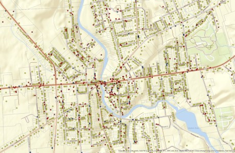
Project Description Vertex Geospatial was contracted to geocode tree planting locations using field collected address data from foresters performing an urban tree inventory. Address and inventory data for each tree or planting site was received in Microsoft Excel format to be geocoded to the NYS Street Centerline file. Standard ArcGIS address locators were used to create a point feature for each tree or planting site in shp file format. Once created, each point feature was viewed on a map with high resolution aerial photography to validate the geocoded locations were accurate. For areas where field GPS verification data was available, each point feature was corrected to the GPS location. If GPS data was not available, the aerial photography and Assessors parcel data was used to match house addresses with tree canopy shadows visible in the aerials. Photographs of each tree were also hyperlinked to the point features in ArcMap to assist the foresters with adding/updating tree attribute data.
Project Details
- Client Uran Forestry LLC
- Date September 3, 2010
- Tags Forestry, Geocoding
Comments are closed.